Court Addresses Property Line Dispute Involving Fence and 100-Year Old Agreement
by Tiffany Dowell Lashmet, Texas Agriculture Law Blog
The El Paso Court of Appeals recently considered Eggemeyer v. Hughes, a case involving a disputed boundary line. At issue was a 100-year old agreement regarding the proper boundary line that referred to certain mesquite trees and rock piles, a fence line drawn on a decades-old survey, and the ownership of 90 acres of land. [Read opinion here.]
Background on Property Line Disputes
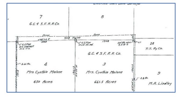
This case involves a dispute over a fence in Reagan County depicted in the 1939 survey map below. Hughes owns Section 7 and Section 8. The Eggemeyers own Sections 3 and 4. The dispute is the east-west boundary line dividing Sections 7 and 8 from Sections 3 and 4. Hughes claims the section line defines the boundary between the properties, and that the barbed wire fence on the survey was built off the property line likely because the terrain made placing the fence on the section line more difficult. There is a stone mound at the intersection of the section line dividing Sections 7 and 4. There is another stone mound at the southernmost intersection between Sections 7 and 8 and the northern most intersections of Sections 3 and 4. The Eggemeyers argue that it is the dashed east-west link labeled as a fence on the survey that is the dividing line of the property. There is an old, dilapidated barbed-wire fence, but no stone mounds along the fence line. The two lines are 150 yards apart, resulting in 90 acres in dispute.

This is not the first time there has been a boundary issue related to these properties. Over 100 years ago, George Tankersley owned Section 7 and James Talley owned Section 4. They filed an agreement (“the 1914 Agreement”) in the Reagan County deed records stating it was “the mutual desire of said parties to permanently fix and settle the boundary line between their respective lands so that the matter may be forever settled and so that no uncertainty may exist with reference thereto.” They described the agreed upon boundary as follows, with “md.” standing for mound, “mes.” meaning a mesquite tree, and a vara being a unit to measure distance:
Commencing at a stake and a stone md. set under the present south fence of the G.
W. Tankersley pasture as it now stands for the S.W. corner of said survey No. 7,
and the N.W. corner of said Sur. No. 4, from which a mes. 6” bears Sotuh [sic] 85
E. 25 1/2 varas, a wide spreading mes. 6” bears S. 75 3/4 E. 49 varas;
Thence East with the fence line as it now stands 1900 varas to a stone md. set 8
varas East of the East bank of a branch and under said fence line, for the N.E. corner
of said Sur. No. 4 and the S.E. corner of said Sur. No. 7.
Through a series of deeds, the Tankersly property is now owned by Hughes and the Talley property is now owned by the Eggemeyers. The Eggemeyers deed did include reference to the disputed acreage.
In 2013, the Eggemeyers met with Hughes to ask if they could place a water well closer to the property line than the 660′ setback required by the groundwater district. This conversation brought the parties different understandings of the property line to light. During this time, Hughes believed that the parties reached an agreement whereby Hughes would build a standard fence along the section line and would also reimburse the Eggemeyers for what they paid for the disputed acreage. The Eggemeyers claim they never agreed to these terms once they understood the amount of acreage at issue.
Lawsuit
Hughes sued the Eggemeyers asserting several claims including trespass to try title, suit to quiet title, a declaratory judgment that the 1914 Agreement is binding, a breach of contract claim regarding the 1914 Agreement, a trespass claim, and fraud and misrepresentation regarding the Eggemeyers statement during negotiations. They Eggemeyers responded, claiming adverse possession based on their predecessors use of the disputed acres, as well as asserting theories of quiet title, trespass, and a declaratory action seeking a declaration that the boundary line is the fence line.
The trial court found for Hughes regarding ownership of the disputed acres and rejected the Eggemeyers adverse possession claim. The court dismissed Hughes’ claims of trespass, breach of contract, and fraud/misrepresentation. The court awarded Hughes 1/3 of the total attorney’s fees he sought at trial.
The Eggemeyers raise two main issues on appeal. First, they challenge the findings awarding ownership to Hughes. They did not appeal the court’s rejection of their adverse possession claim. Second, the court addresses whether attorneys’ fees were properly awarded, an issue we will not discuss in this blog post.
Appellate Court Opinion
The court affirmed the trial court’s decision regarding ownership.
The court states the 1914 Agreement controls the placement of the property boundary between the two parties. That Agreement references a fence that starts at a corner marked by a mound of rocks. No rock mound, however, was identified at the corner or anywhere along the length of the current fence. There are several rock mounds with metal pipe still in place that mark the corners of the respective sections. There is, however, no evidence that a fence ever ran along the length of the section line. Additionally, there is no evidence that the mesquite trees referenced in the 1914 Agreement still exist.
In the absence of evidence surrounding the 1914 Agreement, both parties speculate on how to explain the descriptions. The Eggemeyers expert suggests that the starting point–a stake and mound of rocks–is no longer present because of the current highway that now exists next to the properties. Hughes speculates that the whole purpose of having an agreement was to preserve the section line as the boundary in anticipation of the fence being built off the property line. Additionally, the only rock mounds found today are those located along the section line, and those same mounds are found in several surveys over the last century.
Additionally, the property and acreage descriptions from different deeds over time are not uniform and are also disputed by the parties. Some deeds appear to describe the disputed acreage as belonging to the Eggemeyers, but no deed expressly refers to them owning a portion of Sections 7 or 8.
In light of this disputed evidence, the court noted that it was an extremely close question, but found the evidence factually sufficient to support the trial court’s verdict. Note–the question before the appellate court was not how they would rule, but rather whether there was sufficient evidence to support the trial court’s decision in favor of Hughes owning the disputed acreage. This, the appellate court held, there was.
With regard to the attorney’s fee issue, the court remanded for reconsideration of the amount of attorney’s fees and whether they may be property segregated.
Key Takeaways for Property Lines in Texas
The issue of fences being built off of property lines is quite common across Texas. Oftentimes, the terrain may not allow for a fence to be built along the actual property boundary. There are a number of important considerations from this case.
First, the key holding in this case is not any clear legal doctrine on how courts will analyze boundary disputes. Instead, the key takeaway is the importance of having a detailed, objectively clear agreement when parties attempt to resolve a boundary dispute. The details surrounding any property description used in a deed or agreement are critical. Here, were there more permanent markers or better descriptions than mesquite trees or rock mounds present, it may have helped avoid this dispute. Unfortunately, because the description was so poorly written using non-permanent markers, the boundary line was really no more clear after the description was filed. Certainly, now with better surveying technology, better descriptions are available. Keep this in mind anytime a document is being drafted to be recorded in the deed records.
First, note that just because a fence exists for a substantial period of time–such as 100 years or more–that does not necessarily change the boundary line for the property. This is a common misconception about Texas law. While there may be circumstances that will allow for a change in boundary line due to a fence, such as when a party can prove all of the elements of adverse possession, this is not automatic or common.
Second, although not expressly addressed, this is a good time to recall that proving adverse possession is extremely difficult. To learn more about adverse possession generally, click here for a prior podcast episode. This is particularly true when an agricultural use like grazing is the use that the would-be adverse possessor intends to rely on. To read more about that concept in a prior blog post , click here.
Fourth, this case illustrates a good practice of recording any agreements regarding boundary lines, particularly if a fence will be constructed off the property line and the parties do not intend for this to change the boundary. Having this type of agreement, written in better detail than in this case, recorded in the county property records can help to avoid potential conflicts down the road. n Note, for an agreement to be binding and enforceable on subsequent owners, both parties must understand and agree what it means, and it must be filed in the deed records.
Finally, while it is not always possible, I will go back to the advice that my fellow ag lawyer Jim Bradbury and I offer at every one of our fence law presentations. You’re almost always better off to settle a fence law dispute over a cup of coffee than in the courthouse. Litigation is time consuming and expensive for all involved. In this case, for example, Hughes’ request for attorney’s fees was in the amount of $440,000. Reaching an agreement is not always possible, but where it is, it can save time, money, and frustration for both sides.


